Kolkata/New Delhi. More than one lakh people have been evacuated from vulnerable areas of Bengal to safer places in view of the possibility of cyclone ‘Remal’ intensifying further and hitting the coasts of Bangladesh and West Bengal by Sunday midnight. The coastal areas of Bengal have been put on high alert as the cyclone moving with high speed winds has already caused rain in many parts of the state.
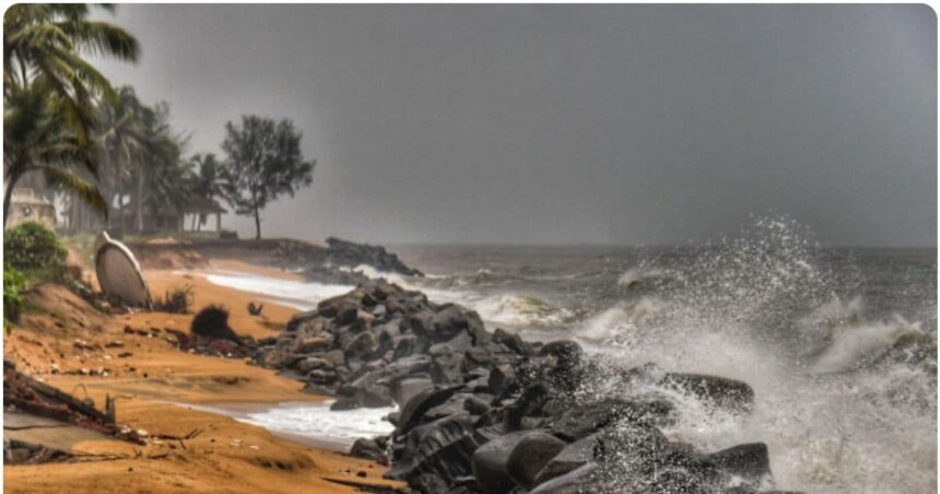
According to the bulletin of the India Meteorological Department (IMD), ‘Remal’ was centered 160 km south-southeast of Sagar Island at 6 pm. Officials said that the speed of the cyclonic storm is 100-110 km per hour, which can reach 120 km per hour. It is expected to hit the coast between Sagar Islands of West Bengal and Khepupara near Mongla port of Bangladesh by Sunday midnight.
By 3 pm, the West Bengal government had evacuated about 1.10 lakh people from coastal and vulnerable areas and moved them to safer places like shelter homes, schools and colleges. Prime Minister Narendra Modi on Sunday chaired a meeting to review the preparations made to deal with cyclonic storm ‘Remal’.
Minister of State Akhil Giri said, “Our experience in dealing with Cyclone Amphan and Cyclone Yaas in the past will be put to good use.” West Bengal Governor Dr CV Anand Bose said he is closely monitoring the situation and is in constant touch with state and central experts to ensure a coordinated response to deal with the cyclone.
Bose stressed the importance of safety for residents in the coastal areas of Bengal and urged them to follow the standard operating procedures (SOPs) in view of the cyclone. The cyclone has already brought light rains and strong winds to areas like Digha, Kakdwip and Jayanagar, which are likely to intensify further on Monday.
Somnath Dutta, head of the eastern region of the Meteorological Department in Kolkata, said that winds will blow at a speed of 45 to 55 kmph in many districts of South Bengal from Sunday evening, which will affect Kolkata, Howrah, Hooghly and East Medinipur. While talking to reporters here, Dutta warned that from Sunday evening to Monday morning, the wind speed in the coastal areas of West Bengal can reach from 100-120 kmph to 135 kmph.
Dutta said, “Remal will cause damage, but it is likely to be less destructive than Cyclone ‘Amphan’ in 2020.” The Meteorological Department has warned of floods and major damage to weak buildings, power and communication lines, unpaved roads, crops and gardens in the South and North 24 Parganas districts of West Bengal. People in the affected areas have been advised to stay indoors and stay away from weak buildings.
14 teams of the National Disaster Response Force (NDRF) have been deployed in districts of South Bengal including Kolkata, North and South 24 Parganas, East and West Medinipur, Howrah and Hooghly. In view of the cyclone, the Eastern and South Eastern Railways have canceled many train services in the coastal districts of South and North 24 Parganas and East Medinipur district as a precautionary measure.
Kolkata airport authorities have decided to suspend flight operations for 21 hours from Sunday afternoon due to the possible impact of cyclone ‘Remal’. A spokesperson of the Airports Authority of India (AAI) said that a total of 394 flights, both international and domestic, will not operate from the airport during the flight suspension period.
Officials of the Kolkata-headquartered North East Region of the Indian Coast Guard (ICG) said they have taken all precautionary measures to ensure that there is no loss of life or property at sea. Cargo and container handling operations will also remain suspended for 12 hours from Sunday evening at the Shyama Prasad Mukherjee Port in Kolkata due to the forecast of the cyclone.
The cyclone was located 240 km south-southeast of Sagar Island in the North Bay of Bengal till 11:30 am on Sunday and during this time the winds blew at a speed of 90-100 km per hour and their speed was up to 110 km per hour. This is the first cyclone to hit the Bay of Bengal in the pre-monsoon season.
The weather office has issued a warning of extremely heavy rainfall in the coastal districts of West Bengal and North Odisha on May 26-27. Extremely heavy rains are also expected in Assam and Meghalaya. Heavy to very heavy rains are expected in Manipur, Nagaland, Arunachal Pradesh and Tripura on May 27-28.
When the cyclone reaches the coastal areas of West Bengal and Bangladesh, waves of up to 1.5 metres high are expected to flood low lying areas. The weather office has advised fishermen not to venture into the sea in the North Bay of Bengal till Monday morning.
Heavy to very heavy rains have been predicted in North and South 24 Parganas, East Medinipur, Kolkata, Howrah and Hooghly districts. A ‘red alert’ has been issued for these areas due to the possibility of extremely heavy rains in North and South 24 Parganas and East Medinipur districts. Nadia and Murshidabad districts may also receive heavy to very heavy rains on 27-28 May.
Eastern Railway has suspended train services in Sealdah South and Barasat-Hasnabad sections from 11 pm on Sunday to 6 am on Monday as a precautionary measure, resulting in cancellation of several local trains. South Eastern Railway has also cancelled the Kandari Express on Sunday and some trains to and from Digha on Sunday and Monday.
Heavy rains are expected in Balasore, Bhadrak and Kendrapara districts in northern Odisha on 26-27 May and Mayurbhanj on 27 May. Extremely heavy rains are expected in North Bengal districts Cooch Behar, Alipurdurwar and Jalpaiguri on 28-29 May. Apart from this, heavy rains are also expected in Darjeeling, Kalimpong, North and South Dinajpur districts.
The IMD has warned of flooding in the South and North 24 Parganas districts of West Bengal and heavy damage to weak structures, power and communication lines, unpaved roads, crops and gardens. People in the affected areas have been advised to stay indoors.
The Indian Coast Guard (ICG) has taken precautionary measures to prevent loss of life and property at sea and fishing vessels and commercial vessels have been alerted at Haldia and Paradip. The ICG has kept ships and aircraft ready along with disaster relief teams for search and rescue operations at Haldia, Fraserganj, Paradip and Gopalpur.
A control room has been set up at the Kolkata Police headquarters in Lalbazar to coordinate the efforts of the state agency. “10 teams of Kolkata Police have been deployed in 10 police divisions of the city,” a senior police officer said.
Teams of the National Disaster Response Force (NDRF) are also going to those districts which are likely to be affected by the cyclone. The NDRF has deployed its teams and equipment in many districts including Kolkata, North 24-Parganas, East Medinipur, West Medinipur, South 24-Parganas, Howrah and Hooghly.
The cyclone is also likely to affect the Sundarbans mangrove forest. The Sundarbans is one of the largest forests in the world and is known for its diverse fauna, including 260 species of birds, the Bengal tiger and other endangered species such as the estuarine (saltwater) crocodile and the Indian python.
Spread over 9,630 square kilometres on the borders of West Bengal and Bangladesh, Sundarbans is one of the areas most affected by sea level rise, salinity and land erosion due to climate change. Scientists say that due to warmer sea surface temperatures, cyclones are intensifying rapidly and maintaining their effect for a longer time.
According to IMD senior scientist D S Pai, warming of the sea surface means more moisture, which is conducive for cyclones to intensify. The Indian Navy has kept two ships equipped with Humanitarian Assistance and Disaster Relief (HADR) and medical supplies ready for immediate deployment for the safety and welfare of the people of the affected area.
Tags: Delhi Hospital, Delhi Police, Kolkata News, NDRF Team, west bengal
FIRST PUBLISHED : May 26, 2024, 23:06 IST