


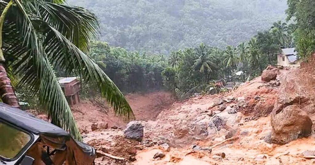
Several days of heavy rain in the hilly area has weakened the soilDeforestation, heavy construction and climate change have made Kerala’s areas disaster proneIn the last ten years, the maximum number of landslides in the country have occurred in Kerala.
Wayanad is the only plateau district in north-eastern Kerala. Situated in the Western Ghats mountain range, this district is on the border of Karnataka and Tamil Nadu. This area with tea gardens is a popular hill station. On the night of 30 July, when people were sleeping peacefully here, a loud sound was heard. The ground started sliding amidst heavy rain. People ran towards safe places. By 6 am, a massive landslide had occurred in Mundakkai, Meppadi and Choorlamala Noolpuzha towns.
What are the reasons for such a huge devastation in Wayanad? This area has often been a victim of floods and landslides. Let us know what a landslide is and what caused this devastation in Wayanad.
When a part of a mountain or soil starts sliding from a slope, it is called a landslide. Landslides occur when the grip of the mountain, slope or soil weakens. When the ‘glue’-like force that binds the particles of rock or soil together is reduced.
So far 174 people have died in the Wayanad disaster.
Heavy rainfall is a major reason
It had been raining in Wayanad for several days. The rain was very heavy and intense. This led to the entire area being flooded. Streams of mud and water started flowing, submerging local homes, fields and tea plantations. When this situation continued for a long time, the heavy rainfall made the soil very soft and weak, making it unable to support the load above, leading to landslides.
geographical situation
About 50% of Kerala’s land area has a slope of more than 20 degrees, which is particularly susceptible to soil erosion and landslides. Wayanad is also located in this way. Rain in these areas loosens the soil and can become unstable and start sliding.
In July 2022, the Ministry of Earth Sciences told the Lok Sabha that Kerala has witnessed the highest number of landslides in the country in the last seven years. Of the 3,782 landslides that occurred between 2015 and 2022, 2,239 (about 59.2 percent) occurred in Kerala.


Status of landslides across the country (AnyTV gfx)
Construction activities are also responsible
A lot of construction has taken place in this sensitive area in the last few years. Being a hill station, hotels and other structures were built, which worsened the situation. It increased soil erosion by obstructing natural drainage.
Rainfall pattern changed due to climate change
Climate change has caused a change in the monsoon pattern, resulting in more intense and concentrated rain over a shorter period of time. Of course, there has not been much change in seasonal rainfall but its distribution has become uneven, with heavy rain falling over fewer days. The sudden, rapid flow of water overwhelms the soil, increasing the risk of landslides.
Warming of the Arabian Sea
Warming of the Arabian Sea leads to the formation of deep cloud systems, which carry more rain and dump it in one place. Atmospheric instability allows for intense rainfall events, which are also linked to the devastating landslides in Wayanad.
Deforestation and land use change
Loss of forest cover in Kerala, especially in Wayanad, has increased the susceptibility to landslides. Deforestation reduces soil stability and water-absorbing capacity, making the terrain more vulnerable to erosion and collapse during heavy rains.
What role does a 20 degree slope play?
Roxy Mathew Kole, a climate scientist at the Indian Institute of Tropical Meteorology in Pune, predicts that extreme rainfall will intensify across India and over the Western Ghats from Kerala to Maharashtra. Nearly half of Kerala is made up of hills and mountainous regions with slopes greater than 20 degrees, making these areas prone to landslides during heavy rains.
Such disasters have increased in Kerala
Extreme weather events, including devastating floods and landslides, have increased significantly in Kerala over the past decade. A devastating flood occurred in 2018, which is said to be the worst flood in history.
Is this the result of ignorance?
Many experts say that all this is the result of ignoring the signs. Because this entire area is ecologically sensitive. Minor landslides have always occurred here. The entire western Kerala is a hilly area with steep slopes, where there is a strong possibility of landslides.
In 2010, the Environment Ministry of the Government of India constituted an expert committee to formulate a strategy for the conservation of the entire Western Ghats, including Kerala. This committee, headed by renowned ecologist Madhav Gadgil, divided the entire Western Ghats into three Ecologically Sensitive Area (ESA) areas.
He said in the report, no development projects of any kind should be allowed in this area. No mining, no power plants and no dams should be built. People associated with the industry and the state governments opposed it. Later the central government rejected this report.
Then a committee was formed under the leadership of scientist Kasturirangan. In the report of the committee formed in April 2013, it was said that only 37 percent of the Western Ghats needs to be declared as ESA. Activities like mining should be banned only there.
Tags: Kerala, Kerala News, Natural calamity, Natural Disaster
FIRST PUBLISHED : July 31, 2024, 21:25 IST