Publish Date: | Thu, 10 Mar 2022 07:00 PM (IST)
Mahesh Solanki Dewas
Along with our forests, NASA’s satellite is keeping an eye on the fire in the entire district. In case of fire incident anywhere in the district, the satellite messages reach immediately to the district and state officials of the forest department. Due to which the team gets involved in the measures to control the fire. The fire incidents of the district can be seen 24 hours a day through the fire map. Earlier, the department could not get information about forest fires many times, but the satellite system has been updated since few years. Fire Alert Message and Management System i.e. Fire Alert Message and Management System has been developed by Madhya Pradesh Forest Department. Which connects to the satellite and gives information about the fire. Immediately information from satellite reaches the officials through message and the team gets involved in preventive measures.
-It’s beneficial
The information had reached the villages after the fire spread in the first forest. She also came late. Sometimes the information did not reach the officials. Due to which more damages and bigger incidents used to come to the fore, but now this work is being done faster with the help of satellite system. In which information reaches all the officials from the state to the district level simultaneously through message. Officials said that the satellite detects the temperature. Due to which messages of burning of Narwai also come.
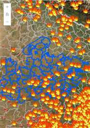
Fire Map has also been launched.
The Forest Department has also launched a fire map a few years back. In which you can watch 24 hours. Where has the fire incident happened? Through the points on the map, it is visible where the fire has started. Officials said that the map has been prepared on the basis of the records of about 10 years.
– This is how the system works
In the fire alert messaging and management system developed by the Madhya Pradesh Forest Department, the satellite detects the fire and shows the active fire places. The system then sends SMS to the concerned field staff and monitoring officers. Area officials can view these fire locations on Google Maps on their computers or mobiles. whereby control measures are taken. Also, the field staff gives feedback online about the action taken at the site of fire and the damage caused by the burning of the area.
Map was prepared on the basis of fire incident in 19 years, more incidents happen in March
Month-total number of fire incidents
Jan-247
February-1212
march-6403
April-2842
May-408
Jun-16
July-0
Aug-0
Sep-0
October-0
November -12
Dec-110
Area-wise fire incidents in 19 years, Udayanagar area has more fires
Forest Parikshatra-Total No. of Fire Incidents
Udayanagar-822
Poonjapura-719
hacked-397
Bagli-215
Satwas-180
Khivni-136
Jinwani-117
Panigaon-86
Khategaon-85
Kannada-58
Dewas-24
Four days ago there was a fire in Khivni, immediately extinguished
Four days ago, a fire broke out in the chamber of hilly area in Khiwani of Kannaud forest area. On which the officials immediately got the message. On which the team immediately brought the fire under control. So that the fire could not spread.
There are many advantages to having a satellite system. We get instant notification of fire through message. Due to which our team takes quick steps regarding fire control.
PN Mishra, DFO, Forest Department
Posted By: Nai Dunia News Network