
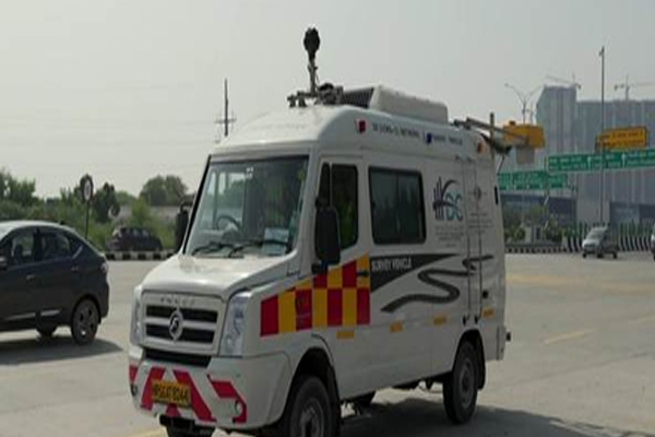
New Delhi . The Ministry of Road Transport and Highways (MoRTH) on Thursday announced that it has deployed advanced Network Survey Vehicles (NSVs) across the country, which are equipped with 3D laser-based technology. This initiative is being considered as a major step towards a data-based and proactive maintenance system of India’s National Highway Network. These state-of-the-art vehicles are equipped with laser profilers, GPS systems, high-resolution cameras and advanced 3D laser sensors that aim to survey the highways and create detailed digital maps of road conditions. The system can identify defects such as potholes, cracks, patchwork and unevenness in the road surface, enabling the concerned agencies to take timely corrective action.
According to the ministry, the initiative aims to improve the travel experience and strengthen road safety on national highways across the country.
NSV (National Service Vehicle) vehicles have already been deployed in many National Highway corridors and it is expected that this technology will completely change the way road assets are monitored and maintained.
While traditional survey methods could survey only 20 to 80 kilometers of road per day, these new generation vehicles are capable of surveying up to 300 kilometers per day.
The ministry said that with this increased capacity, road defects can be detected faster and the time taken for repair works will also be significantly reduced.
According to the ministry, this technology has also brought major improvements in the process of data processing and report preparation. The raw survey data collected by the vehicles is encrypted and sent to the central NSV center within 48 hours.
After this, expert teams deployed in five areas analyze this data and prepare reports. Whereas earlier this entire process used to be completed in 4 to 6 months, now it can be completed in just 10 days.
Each report will also go through a rigorous quality check process before approval to ensure accuracy of the reports.
Once the reports are verified, notices will automatically be issued to the concerned stakeholders through the digital platform. This will reduce human intervention and make the entire process more transparent.
A key feature of the new system is that it has been linked to the AI-based data lake portal of the National Highways Authority of India (NHAI).
All survey related information will be directly uploaded on this platform, allowing experts to analyze the road condition in real time and take fact-based maintenance and repair decisions.
—
Read this also – Click to read the news of your state/city before the newspaper.